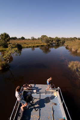
 This post is a little out of order. It’s a long one to explain so I’ve had to take more time to write it. On our second day back from leave we took a boat cruise up one of the major channels in the Delta (the Muanachira {mona-chira}) to see what the flood and water levels were doing. (Any of my old work mates reading this will laugh and know how I feel about boat cruises, and the idea of me being confined to a small space with nowhere to go but jump overboard. And here it wouldn’t be the pollution that would kill me, it would be the crocodiles) Anyway, one of the main topics of conversation (besides cars) among the locals when we are in Maun is the water. How’s the water in Moremi? What is the flood doing? Huge flood coming.. There are charts showing the flood levels posted in most locations, behind bars etc. These are referenced when the conversation about the water is raised.
I am sure you are all wondering what water is doing in the Kalahari desert? My thoughts as well before I arrived and thus learnt about the water in the Okavango Delta, in fact the delta is a complex web of waterways and islands that form one of the most beautiful and pristine wildlife areas left in Africa and lies within one of the largest continuous stretches of sand in the world, the Kalahari desert basin. The water of the Okavango literally floats on a saturated sea of sand.
Disclaimer: Graham helped me write this.
 The Okavango is the largest inland delta on Earth. It is nestled in the center of the Kalahari sand basin and is a vast oasis in this arid semi-desert.
There are a network of permanent rivers winding through the Okavango delta throughout the year but the overall water level of the region depends on the flood waters that descend from thousands of kilometers to the North-west in the Angolan highlands and the rainfall that falls in the delta it’s self.
North of Botswana, the river is a traditional African river but as soon as it hits the Kalahari sand at Mohembo, in Northern Botswana, the water is no longer confined by rocky banks and it begins to spread out. Here the swamp is confined to a 10km corridor by two parallel fault lines known as the panhandle. The river winds and meanders through floating papyrus and reed banks. This area is only navigable by boat and traditional dugout canoes called mekoro.
At Seronga, the base of the panhandle and start of the delta proper, the water breaks the bounds of the faults and splays across the sands. Rivers, channels, flood-plains and lagoons form around islands ranging in size from a few meters in diameter to several kilometers. When viewed from satellite images, the delta resembles a hand, The fan (or delta as it is more commonly called), resembles the shape of a hand. The palm is a permanent delta of constant water, and the fingertips are seasonally flooded swamps and lush floodplains.

 The flood gradually makes it’s way down from the North in two main thrusts, spreading out over the land in different directions every year; much like water spilt on a flat table. The delta changes from year to year depending on flood levels and rains and the flood constantly forges new channels which prevents the delta becoming silted up. This dynamic nature leads to great diversity of water depth, soils, vegetation and animal distribution and thus change is the essence of the Okavango Delta. In January the start of the main flood begins, spreading down the top of the panhandle and into the main part of the Delta itself at around April each year. It is from this point on that high flood reaches the lodges and water activities become the primary activity in most camps and the hot topic of conversation among the locals; high flood reaches the bottom of the Delta near Maun in June.
 Maun is a safari town on the southern edge of the delta and lies on the Thamalakane river which is the main out flow of the delta. The floodwater trickles slowly down the length of the delta and eventually reaches Maun several months later. In over 250 kilometers from the base of the panhandle to Maun there is only a 40 meter drop in altitude.
The highest point of the flood throughout the majority of the delta varies but over the last five years it has consistently been at around May each year. The water level then stays high for a couple of months and then gradually recedes, drying out the flood-plains as the water evaporates; most of the Delta dries by around late October and November each year.
And so this my friends and family is why and how there is water in the Kalahari.
 Being one who loves the water and loves to swim, and one who is so used to being able to dive right into any fresh water I see on any hot day, here it’s a tease. On these and those hot summer afternoons as we meander past Jesse’s pools and all I want to do is dive in to cool off, I can’t. If the hippos don’t get me the crocodiles will. So I look on longingly at the beautiful water, and wish I were one of the lilly pads floating lazily in the cool crisp water.


No comments:
Post a Comment